
Stay ahead with today’s Mexico weather forecast: heavy rain, thunderstorms and heat waves impacting Coahuila through Chiapas and beyond.
A powerful mix of meteorological systems will sweep across Mexico today, May 26, 2025, unleashing heavy rain, thunderstorms, hail and soaring temperatures in many states. A dry line over Coahuila, coupled with a low-pressure trough parked across northeastern Mexico, will trigger showers and downpours in Coahuila, Nuevo León, Tamaulipas and San Luis Potosí. In northern Coahuila, gusts between 60 and 80 km/h may even spawn whirlwinds.
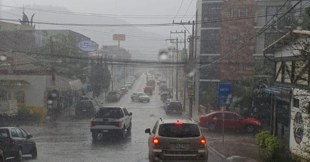
Meanwhile, low-pressure troughs hovering over the Northern Mesa, Central Mesa and southeastern Mexico—supercharged by atmospheric instability and moisture surging in from the Pacific, the Gulf of Mexico and the Caribbean—will drench those regions along with much of western, southern and eastern Mexico. In Hidalgo, Puebla, Veracruz, the State of Mexico, Oaxaca and Chiapas, rainfall could reach 50 to 75 mm, overwhelming streets and rivers.
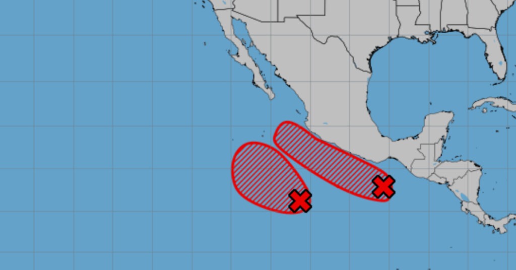
To the south of Chiapas and Oaxaca, a budding low-pressure zone with potential for cyclonic development will keep building clouds and boost very heavy rainfall there. At the same time, an intense heat wave will grip swaths of the country: Coahuila’s southwest corner; Durango’s northeast and southwest; Sinaloa; northern Nayarit; Jalisco’s southwestern, central and southern areas; Colima; western and southern Michoacán; Guerrero; southern and southeastern Oaxaca; western and central Chiapas; and northern Campeche can expect highs between 40 °C and 45 °C.
Rainfall Warnings
- Very heavy rain (50–75 mm): Hidalgo, Puebla, Veracruz, State of Mexico, Oaxaca, Chiapas.
- Heavy rain (25–50 mm): Nuevo León, San Luis Potosí, Guanajuato, Querétaro, Mexico City, Tlaxcala, Morelos, Michoacán, Guerrero, Tabasco.
- Showers (5–25 mm): Coahuila, Tamaulipas, Jalisco.
- Isolated showers (0.1–5 mm): Durango, Zacatecas, Aguascalientes, Colima, Campeche, Quintana Roo.
Flooding, ponding and landslides are likely where rain piles up. Rising rivers may surge over their banks, and urban drains could clog, stranding motorists.
Wind and Wave Alerts
- Coahuila (north): Winds 30–40 km/h, gusts 60–80 km/h, possible whirlwinds.
- Nuevo León, Tamaulipas: Southerly 20–30 km/h, gusts to 70 km/h.
- Veracruz, Oaxaca (Isthmus): South winds 10–20 km/h, gusts to 50 km/h.
- Baja California peninsula, Sonora, Chihuahua, Durango, Zacatecas, Sinaloa, Nayarit, Colima, Jalisco, Michoacán: Winds 10–20 km/h, gusts 40–60 km/h, dust-storm risk.
- Central states (San Luis Potosí through Puebla): Winds 10–20 km/h, gusts 30–50 km/h.
- Marine: Waves 2.0–3.0 m off Chiapas and Oaxaca; 1.5–2.5 m along Baja California’s west coast and the Pacific coasts of Jalisco, Colima, Michoacán and Guerrero.
Strong gusts could topple trees, billboards and power lines. Fire risk may climb where winds dry out vegetation in northern and western states.
Regional Forecasts
Mexico City & State of Mexico
Expect fog and haze in high-altitude areas until mid-morning, with lingering lows of 13–15 °C in the capital and 9–11 °C around Toluca. Skies will clear to mild in the afternoon before heavy showers roll in, followed by very heavy rain outside the city. Lightning and hail are possible. Maximum temperatures will climb to 22–24 °C in Mexico City and 19–21 °C in Toluca. Southwesterly winds 10–20 km/h, gusting to 50 km/h, will add a chilly edge.
Baja California Peninsula
Partly cloudy skies will keep rain at bay. Morning temps will hover in the cool-to-mild range, jumping to the mid-30s °C by afternoon. West-northwest winds 10–20 km/h, gusting to 60 km/h, may kick up dust storms in exposed areas. Offshore, waves will reach up to 2.5 m.
North Pacific (Sonora & Sinaloa)
Sunny conditions will dominate, with morning highs in the 20s °C. By afternoon, heat wave conditions will push temperatures into the low 40s °C in Sonora and the high 30s °C in Sinaloa. West-southwest winds 10–20 km/h, gusting 60 km/h, could whip up dust near Sonoran deserts.
Central Pacific (Nayarit, Jalisco, Colima, Michoacán)
Clouds will thicken over Michoacán, bringing heavy rain, thunderstorms and hail that could trigger floods and landslides. Jalisco will see scattered showers, Colima isolated sprinkles and Nayarit dry spells. Morning temps 20–25 °C will jump to 35–40 °C in the afternoon, with heat waves in Nayarit’s north, Jalisco’s south and Colima. Winds 10–20 km/h, gusting to 60 km/h, will rattle palm fronds. Coastal swells may top 2 m.
South Pacific (Guerrero, Oaxaca, Chiapas)
Heavy to very heavy showers and storms will drench the Pacific coast, raising landslide and flood concerns. Morning lows in the mid-20s °C will give way to highs of 35–40 °C inland. Variable winds 10–20 km/h, gusting to 50 km/h, will prevail, with southerly bursts in Oaxaca and stronger gusts up to 60 km/h in Chiapas. Offshore waves near 3 m will churn beaches.
Gulf Coast (Tamaulipas, Veracruz, Tabasco)
Tamaulipas can expect steady rain and gusts to 70 km/h; Veracruz will alternate showers with thunderstorms and possible hail—winds gusting to 50 km/h—and Tabasco heavy showers. Daytime highs will hit 35–40 °C under muggy skies.
Yucatán Peninsula (Campeche, Yucatán, Quintana Roo)
Partly cloudy skies will deliver isolated showers in Campeche and Quintana Roo, while Yucatán stays dry. Morning temps in the mid-20s °C will soar to 35–38 °C by afternoon, with a heat wave slamming Campeche’s north. East-southeast winds 10–20 km/h, gusting to 60 km/h, will ruffle palms.
Mesa del Norte (Northern Mesa)
Nuevo León and San Luis Potosí will see heavy rain, lightning and hail. Coahuila will alternate showers with gusty winds capable of spawning whirlwinds in the north. Chihuahua stays mostly dry, though Durango, Zacatecas and Aguascalientes could see isolated showers. Morning temps range from 12 °C in the mountains to 25 °C on the plains; afternoon highs will top 40 °C in Coahuila and Durango. Easterly winds 30–40 km/h, gusting to 80 km/h in Coahuila’s north, will stir dust and sand.
Central Mesa (Mesa Central)
Hidalgo and Puebla will endure very heavy rain, thunderstorms and hail, risking floods and mudflows. Guanajuato, Querétaro, Tlaxcala and Morelos can expect heavy showers. Morning conditions will feel cool; afternoons will warm to 28–32 °C. Winds 10–20 km/h, gusting to 50 km/h, will buffet loose debris.
Recent Extremes
In the past 24 hours, Tapachula, Veracruz recorded 66 mm of rain; Necaxa, Puebla 48 mm; and San Cristóbal de las Casas 35 mm. On the temperature front, Choix, Sinaloa hit 42.3 °C, while Monclova, Coahuila reached 41.4 °C.
Stay Safe
With heavy rainfall, strong winds and intense heat zones in play, residents should monitor local alerts, avoid flood-prone areas and secure loose outdoor objects. Keep an umbrella close, limit outdoor exertion during peak heat and heed civil protection warnings until conditions stabilize.