


Today, Saturday, July 13, 2024, a combination of Tropical Wave No. 9, low-pressure channels, upper-level divergence, and the entry of humidity from both the Pacific Ocean and the Gulf of Mexico will bring heavy to very heavy rains across much of Mexico. Several regions, including Chihuahua, Durango, Nayarit, Jalisco, Oaxaca, Puebla, and Veracruz, are expected to experience intense rainfall.
24-Hour Forecast (14:00 July 13 – 08:00 July 14, 2024)
A low-pressure channel extending over the Sierra Madre Occidental, combined with upper-level divergence and moisture from the Pacific Ocean and the Gulf of Mexico, will result in showers and heavy to very heavy rains, accompanied by electrical discharges in the northwest, north, northeast, center, and west of the country, including the Baja California Peninsula. Intense rainfall is forecasted for Chihuahua, Durango, Nayarit, and Jalisco.
Tropical Wave No. 9, moving through the south of the country, will interact with a low-pressure channel over the Gulf of Mexico and southeastern Mexico, along with humidity from the Pacific Ocean and the Caribbean Sea. This will cause heavy to very heavy rains in the east, south, and southeast of Mexico, as well as the Yucatán Peninsula, with intense rains in Oaxaca, Puebla, and Veracruz.
In addition, hot to very hot weather will persist in the northwest, north, and northeast regions of the country, with temperatures exceeding 40°C in areas of Baja California, Baja California Sur, and Sonora.
Meteorological Effects:
Very Heavy Rains (75 to 150 mm):
- Chihuahua
- Durango
- Nayarit
- Jalisco
- Oaxaca
- Puebla
- Veracruz
Heavy Rains (50 to 75 mm):
- Sonora
- Sinaloa
- Coahuila
- Zacatecas
- San Luis Potosí
- Aguascalientes
- Colima
- Michoacán
- Guerrero
- Chiapas
- Tabasco
Intervals of Showers (25 to 50 mm):
- Tamaulipas
- Guanajuato
- Querétaro
- Hidalgo
- State of Mexico
- Tlaxcala
- Mexico City
- Morelos
- Campeche
- Quintana Roo
Showers (5 to 25 mm):
- Baja California
- Baja California Sur
- Nuevo León
- Yucatán
Wind Gusts (50 to 70 km/h):
- Gulf of California
- Campeche
- Yucatán
Wind Gusts (30 to 50 km/h):
- Quintana Roo
- Dust storms possible in several states including Baja California, Sonora, Chihuahua, and others.
Maximum Temperatures:
- 40 to 45°C: Baja California, Baja California Sur, and Sonora
- 35 to 40°C: Sinaloa, Chihuahua, Coahuila, Nuevo León, Tamaulipas, Campeche, and Yucatán
- 30 to 35°C: Nayarit, Jalisco, Colima, Michoacán, Guerrero, Oaxaca, Chiapas, San Luis Potosí, Veracruz, Tabasco, and Quintana Roo
Important Notes:
- Rains may be accompanied by lightning, wind gusts, and possible hail.
- Increased levels of rivers and streams, landslides, puddles, and flooding in low-lying areas are expected.
48-Hour Forecast (08:00 July 14 – 08:00 July 15, 2024)
Low-pressure channels over the Sierra Madre Occidental, the Mesa del Norte, and the Sierra Madre Oriental, along with upper-level divergence and moisture from the Pacific Ocean and the Gulf of Mexico, will continue to bring showers and heavy to very heavy rains across the northwest, north, northeast, east, center, west, and south of the country. Tropical Wave No. 9 will move south of Michoacán and Colima, enhancing rain potential in these regions.
A new tropical wave will approach the coasts of Quintana Roo, reinforcing rain potential in the Yucatán Peninsula.
Meteorological Effects:
Heavy to Very Heavy Rains (50 to 75 mm):
- Sonora
- Chihuahua
- Coahuila
- Durango
- Sinaloa
- Nayarit
- Jalisco
- Colima
- Michoacán
- Guerrero
- Oaxaca
- Chiapas
- Veracruz
- Tabasco
Intervals of Showers (25 to 50 mm):
- San Luis Potosí
- Zacatecas
- Guanajuato
- Querétaro
- Hidalgo
- Puebla
- Tlaxcala
- State of Mexico
- Mexico City
- Morelos
- Campeche
- Yucatán
- Quintana Roo
Showers (5 to 25 mm):
- Baja California
- Baja California Sur
- Aguascalientes
- Nuevo León
- Tamaulipas
Wind Gusts (50 to 70 km/h):
- Gulf of California
- Isthmus and Gulf of Tehuantepec
Wind Gusts (40 to 60 km/h):
- Possible dust storms in several states including Sonora, Chihuahua, Coahuila, and others.
Maximum Temperatures:
- 40 to 45°C: Baja California and Sonora
- 35 to 40°C: Baja California Sur, Sinaloa, Coahuila, Nuevo León, Tamaulipas, Campeche, and Yucatán
- 30 to 35°C: Chihuahua, Durango, San Luis Potosí, Nayarit, Jalisco, Colima, Michoacán, Guerrero, Oaxaca, Chiapas, Veracruz, Tabasco, and Quintana Roo
Important Notes:
- Rains may be accompanied by lightning, wind gusts, and possible hail.
- Increased levels of rivers and streams, landslides, puddles, and flooding in low-lying areas are expected.
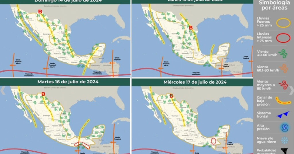
72-96 Hour Forecast Summary (July 15-17, 2024)
During this period, a new tropical wave will move over the southeast and south of Mexico, interacting with low-pressure channels, upper-level divergence, and moisture from the Pacific Ocean and the Gulf of Mexico. This will cause heavy to very heavy rains with electrical discharges in these regions, as well as in the Yucatán Peninsula, the east, and the center of the country, with intense rainfall expected in Chiapas, Oaxaca, and Guerrero.
Meteorological Effects:
Monday, July 15:
- Heavy to Very Heavy Rains (50 to 75 mm): Sonora, Chihuahua, Coahuila, Durango, Sinaloa, Nayarit, Jalisco, and Michoacán.
- Intervals of Showers (25 to 50 mm): Several states including Zacatecas, Aguascalientes, Colima, and others.
Tuesday, July 16:
- Intense Rains (75 to 150 mm): Oaxaca and Chiapas.
- Heavy to Very Heavy Rains (50 to 75 mm): Sonora, Chihuahua, Coahuila, Durango, Veracruz, and Tabasco.
Wednesday, July 17:
- Intense Rains (75 to 150 mm): Guerrero and Oaxaca.
- Heavy to Very Heavy Rains (50 to 75 mm): Chihuahua, Coahuila, Nuevo León, San Luis Potosí, Puebla, State of Mexico, Morelos, and Chiapas.
Important Notes:
- Rains may be accompanied by lightning, wind gusts, and possible hail.
- Increased levels of rivers and streams, landslides, puddles, and flooding in low-lying areas are expected.
Stay updated with the latest weather reports and take necessary precautions to ensure safety during these periods of intense weather conditions.