
Stay informed with Weather Mexico June 3 2025 forecast: heavy rains in the southeast, heat waves in northern states, strong wind gusts, and regional alerts.
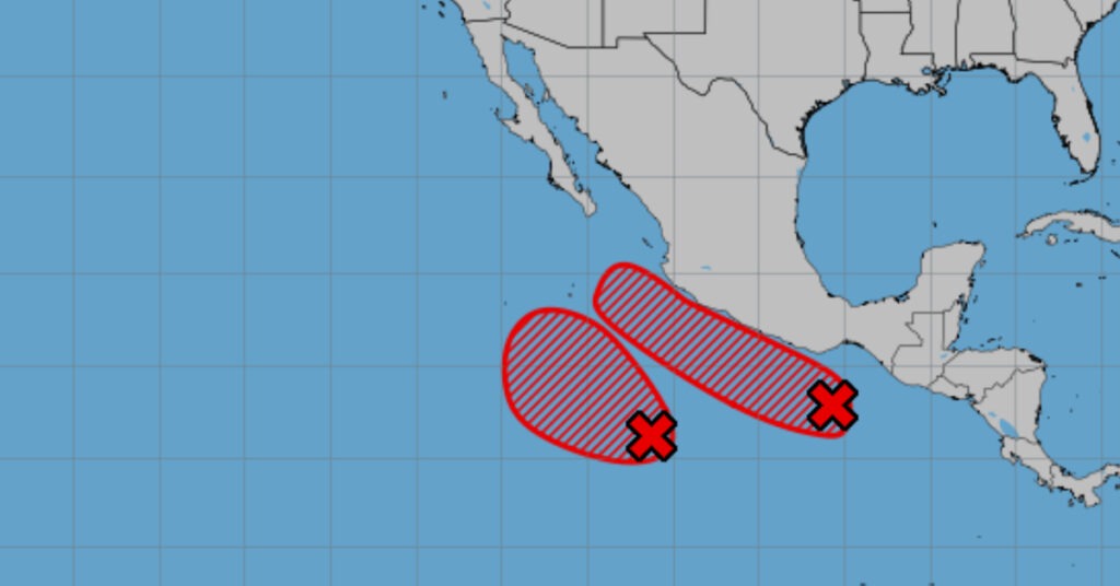
A complex mix of weather systems is shaping conditions over Mexico on June 3, 2025. A mid- to high-level cyclonic circulation riding the subtropical jet stream, a dry line over Coahuila, and an extensive low-pressure channel are combining with atmospheric instability to trigger heavy rainfall and strong winds. Meanwhile, tropical wave no. 2 and monsoon moisture are driving intense downpours in the southeast, and widespread heat waves persist in central and northern regions. High waves will pummel both coasts. Below is a breakdown of today’s weather across the country.
Nationwide Synopsis
A cyclonic circulation aloft—enhanced by the subtropical jet—over central Mexico is fueling instability that, together with a dry line in Coahuila and a broad low-pressure trough, will spark showers and heavy rains across the northeast. Strong wind gusts up to 70 km/h are expected in the northwest, north, and northeast, with a risk of whirlwinds or tornadoes in Coahuila. At lower levels, multiple low-pressure channels colliding with Pacific and Gulf humidity will spread showers and heavy to very heavy rains over western, central, eastern, and southern states, including the Valley of Mexico. Simultaneously, tropical wave no. 2 interacting with another low-pressure channel and an approaching monsoon trough will unleash very heavy to intense rains and high winds in the southeast, including the Yucatán Peninsula. Meanwhile, hot to very hot conditions will prevail over much of the country, with heat waves flagged in at least fourteen states. High-energy waves—1.5 to 2.5 meters—will batter the western coast of Baja California and the shores of Tamaulipas, Sinaloa, Nayarit, Jalisco, Colima, Michoacán, Guerrero, Oaxaca, Chiapas, and Quintana Roo.
Rainfall Forecast and Warnings
- Very Heavy to Intense Rains (75 – 150 mm): Oaxaca, Veracruz, Chiapas, Tabasco, Campeche, Yucatán, Quintana Roo
- Heavy to Very Heavy Rains (50 – 75 mm): Michoacán, Guerrero, Morelos, Puebla
- Showers with Heavy Rainfall (25 – 50 mm): Coahuila, Nuevo León, Tamaulipas, Jalisco, Colima, Guanajuato, State of Mexico, Mexico City, Tlaxcala
- Intervals of Showers (5 – 25 mm): San Luis Potosí, Zacatecas, Aguascalientes, Querétaro, Hidalgo
- Isolated Showers (0.1 – 5 mm): Baja California
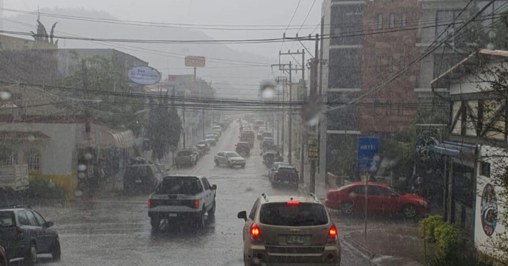
Heavy to intense rainfall can produce ponding, flooding, and landslides, raising river and stream levels. Residents in southeastern states should prepare for rapid water-level rises and possible evacuations in low-lying areas. In northern and northeastern regions—particularly Coahuila—strong gusts risk knocking down trees and billboards, while turbulent air could spawn dust devils or tornadoes.
Heat Wave Threats
A pronounced heat wave will persist today in:
- Northern States: Chihuahua (south, southeast), Coahuila (west, southwest), Nuevo León (south), Tamaulipas (south, southwest), Durango, Zacatecas, San Luis Potosí, Aguascalientes
- Western and Central States: Sinaloa, Nayarit, Jalisco (south, west), Colima, Michoacán (west, center, southeast), Guerrero (west, north), Oaxaca (center, south)
Maximum temperatures will soar between 40 °C and 45 °C in Chihuahua (southwest), Coahuila (southwest), Tamaulipas (south), San Luis Potosí (east), Durango (northwest), Sinaloa, Michoacán, and Guerrero. Regions baked at 35 °C to 40 °C include Baja California, Baja California Sur, Sonora (east), Nuevo León, Zacatecas, Aguascalientes, Nayarit, Jalisco, Colima, Guanajuato, Querétaro, Hidalgo, Morelos, Oaxaca, Chiapas, Veracruz, Tabasco, Campeche, Yucatán, and Quintana Roo. Only the southern part of the State of Mexico and Puebla will see milder highs of 30 °C to 35 °C.
Over the Yucatán Peninsula, persistent cloudiness and rain will finally break the heat wave by day’s end, offering some relief to residents. Elsewhere, people should stay hydrated, limit outdoor work between noon and early afternoon, and watch for heat-related illnesses.
Wind, Wave, and Marine Conditions
- Coahuila: Winds 20 – 30 km/h, gusts 50 – 70 km/h, with possible whirlwinds or tornadoes
- Baja California & Surrounding Desert States (Sonora, Sinaloa, Chihuahua, Durango, Zacatecas, Aguascalientes, San Luis Potosí): Winds 10 – 20 km/h, gusts 40 – 60 km/h, with possible dust devils
- Tabasco, Campeche, Yucatán, Quintana Roo: Winds 10 – 20 km/h, gusts 40 – 60 km/h
- Nuevo León, Tamaulipas: Southerly winds 10 – 20 km/h, gusts 40 – 60 km/h
High-energy waves reaching 1.5 – 2.5 meters will buffet both the Pacific and Gulf coasts: western Baja California peninsula; coasts of Tamaulipas, Sinaloa, Nayarit, Jalisco, Colima, Michoacán, Guerrero, Oaxaca, Chiapas, and Quintana Roo. Maritime interests should secure small craft and heed port advisories.
Regional Outlook
Mexico City Valley
In the Valley of Mexico, early morning skies will be partly cloudy with cool to mild air and fogbanks in higher elevations. By afternoon, expect cloudy skies with showers and heavy rain in both Mexico City and the State of Mexico—possibly accompanied by lightning and localized hail. These downpours could reduce visibility, cause ponding on streets, trigger landslides in steep areas, and raise river and stream levels. Mexico City’s temperatures will range from a low of 13 °C to a high of 26 °C–28 °C. Toluca will dip to 10 °C–12 °C before climbing to 21 °C–23 °C. Winds will be variable at 10 – 20 km/h, with gusts of 30 – 50 km/h.
Baja California Peninsula
Expect partly cloudy skies throughout Baja California and no rain for Baja California Sur. Morning fog will linger along western coastal areas. Afternoon highs will climb to warm or hot levels. West to northwest winds will blow at 10 – 20 km/h, gusting 40 – 60 km/h, with possible dust storms inland. The Pacific side will face 1.5 – 2.5 m waves, threatening small vessels.
North Pacific
Skies over Sonora and Sinaloa will remain partly cloudy, with no significant precipitation. Highlands in Sonora may see cool, mild conditions in the morning. By afternoon, an intense heat wave will set in across Sinaloa. Winds from the west and southwest at 10 – 20 km/h (gusts 40 – 60 km/h) will kick up dust storms. Coastal Sinaloa waters will experience 1.5 – 2.5 m waves.
Central Pacific
Central Pacific states face cloudy skies and spotty—but heavy—rainfall. Michoacán will bear very heavy downpours, while Jalisco and Colima see heavy rains, sometimes with lightning, strong gusts, and hail. These showers may lead to flash flooding, landslides, and poor road visibility. Nayarit should remain dry. Morning fog will linger in pockets; afternoons will grow hot to very hot, with a heat wave in Nayarit, south/west Jalisco, Colima, and parts of Michoacán. Winds will stay around 10 – 20 km/h, gusting to 40 km/h. Coastal regions should anticipate 1.5 – 2.5 m surf.
South Pacific
Oaxaca and Chiapas will see heavy rain, while Guerrero faces very heavy rainfall, all potentially accompanied by lightning, strong gusts, and possible hail. Rapid water surges in creeks and rivers could trigger landslides, flooding, road washouts, and reduced visibility. Mornings will be cool with fog and mild coastal breezes; afternoons will heat up with a heat wave in Guerrero (west, north) and Oaxaca (center, south). Inland winds will range 10 – 20 km/h, gusting to 40 km/h. Pacific swells of 1.5 – 2.5 m threaten the coasts of Guerrero, Oaxaca, and Chiapas.
Gulf of Mexico
Veracruz, Tabasco, and Tamaulipas will endure heavy rain (lightning, strong gusts, and hail possible). Flash floods, landslides, and poor visibility can arise. Morning temperatures will be warm, turning hot to very hot by afternoon, with a heat wave in southern/southwestern Tamaulipas. Southerly winds in Tamaulipas at 10 – 20 km/h (gusts 40 – 60 km/h) will interact with easterly and northeasterly winds in Tabasco (10 – 20 km/h, gusts 40 km/h), while Veracruz sees gusts up to 40 km/h. Gulf waters off Tamaulipas will be rough at 1.5 – 2.5 m.
Yucatán Peninsula
Cloudy conditions will drive heavy rains in Campeche, Yucatán, and Quintana Roo, accompanied by lightning, strong gusts, and possible hail. Flooding, road ponding, and reduced visibility are likely. Morning temperatures remain warm; afternoon highs will be hot. The ongoing heat wave in this region ends today. Easterly and northeasterly winds at 10 – 20 km/h (gusts 40 – 60 km/h) will persist, and coastal waters off Quintana Roo will churn with 1.5 – 2.5 m waves.
Northern Tablelands
Coahuila and Nuevo León will face heavy rainfall with lightning, strong wind gusts, and possible hail—risks include flash floods, landslides, and road washouts. San Luis Potosí, Zacatecas, and Aguascalientes can expect showers with lightning and hail. Chihuahua and Durango remain dry. Predict cool to cold mornings in higher elevations of Chihuahua and Durango; afternoons will heat up, with a heat wave in Chihuahua (south, southeast), Coahuila (west, southwest), Nuevo León (south), Durango, Zacatecas, San Luis Potosí, and Aguascalientes. Coahuila may see 20 – 30 km/h winds gusting to 70 km/h, with potential whirlwinds or tornadoes. Other desert zones will have 10 – 20 km/h winds, gusting 40 – 60 km/h, possibly causing dust storms.
Central Mesa
Morelos and Puebla will record very heavy rainfall; Guanajuato and Tlaxcala will see heavy downpours—all with lightning, strong gusts, and possible hail. Flash flooding and landslides pose a serious threat. Querétaro and Hidalgo will get scattered showers with lightning and hail. Mornings will be cool; afternoons shift to mild or warm. Variable winds at 10 – 20 km/h (gusts up to 40 km/h) remain moderate.
Recent Observations
- Maximum 24-hour Rainfall (mm):
– Radiocommunications, Benito Juárez, Mexico City: 70.0 mm
– Madín Dam, Naucalpan de Juárez, State of Mexico: 58.0 mm
– Chalchihuitán, Chiapas: 44.0 mm - Maximum Temperatures (°C):
– Torreón, Coahuila: 41.5 °C
– Mérida, Yucatán: 40.6 °C
– Soto La Marina, Tamaulipas & Tuxtla Gutiérrez, Chiapas: 39.8 °C
– Ejido Nuevo León, Baja California: 38.3 °C
– Campeche, Campeche & Villahermosa, Tabasco: 38.2 °C
– Matlapa, San Luis Potosí: 38.1 °C
– Chihuahua, Chihuahua & Culiacán, Sinaloa: 38.0 °C
– Hermosillo, Sonora: 37.0 °C
– Tacubaya, CDMX: 28.4 °C - Minimum Temperatures (°C):
– Toluca, State of Mexico: 10.8 °C
– Tacubaya, Mexico City: 14.0 °C
– Pachuca, Hidalgo: 14.2 °C
– Tlaxcala, Tlaxcala: 15.0 °C
– Constitución, Baja California Sur & Zacatecas (town of Constitución): 16.1 °C
– San Luis Potosí, SLP: 16.9 °C
Impacts and Advice
- Flooding & Landslides: Very heavy rains in the southeast (Oaxaca, Veracruz, Chiapas, Tabasco, Campeche, Yucatán, Quintana Roo) and heavy rains in central states can cause abrupt flooding and landslides in mountainous terrain. Travelers should avoid driving on inundated roads and heed local evacuation orders.
- Rising Rivers & Streams: Rivers in southern and eastern states (e.g., in Veracruz and the Yucatán) will rise rapidly. Communities near waterways should monitor local alerts and be ready to relocate.
- Wind Damage & Wildfire Risk: Intensified winds in Sonora, Chihuahua, Sinaloa, Campeche, and Quintana Roo will heighten wildfire danger by spreading dry fuels. Strong gusts in Coahuila and Nuevo León risk toppling trees, power lines, and signs. Residents in affected regions should secure loose objects and avoid outdoor grilling or open fires.
- Marine Hazards: Coastal small-craft operators must stay in port as high waves of 1.5–2.5 m threaten boats. Beachgoers along both coasts should heed rip-current warnings.
- Heat-Related Stress: Northern heat waves reaching 45 °C may cause heat exhaustion or heat stroke. Hydration, wearing light clothing, and avoiding outdoor exertion during peak heat are essential.
By evening, many regions will still contend with lingering showers and gusty winds. However, coastal areas along the Gulf and Pacific may gradually see conditions improve as the afternoon tropical activity shifts eastward. As the day closes, temperatures in the Valley of Mexico will fall into the mid teens, offering relief after the daytime showers and gusts.
Today’s Weather Mexico June 3 2025 outlook underscores a volatile mix of extreme rain, heat, and wind. Residents should monitor local forecasts, follow civil protection advisories, and stay alert to rapidly changing conditions. Stay safe and plan activities around these alerts—especially in high-risk areas for flooding, strong winds, and extreme heat.