
A comprehensive weather roundup for May 16, 2025, as Mexico endures a widespread heat wave, scattered thunderstorms, strong winds and regional rainfall.
Today’s weather pattern over Mexico is dominated by a potent heat wave, scattered storms in the north and west, and strong wind advisories from Baja California to the Yucatán Peninsula. A polar trough over northern Baja California, in combination with the polar and subtropical jet streams and the influence of Cold Front 43, is driving gusty winds and dust storms across much of the country’s northern tier. Meanwhile, low-pressure channels tapping moisture from the Pacific, Gulf of Mexico and Caribbean Sea foster afternoon showers and thunderstorms—some accompanied by lightning, hail and heavy downpours.
Across the northern states of Baja California, Chihuahua, Coahuila, Nuevo León, Tamaulipas and San Luis Potosí, strong to very strong northwesterly winds will gust between 50 and 70 km/h. Dust storms may reduce visibility, while isolated showers and thunderstorms carry the risk of lightning strikes into the evening. By late tonight and early Saturday morning, Cold Front 43 will shift into southern Texas, lifting its direct influence from Mexico’s border regions.
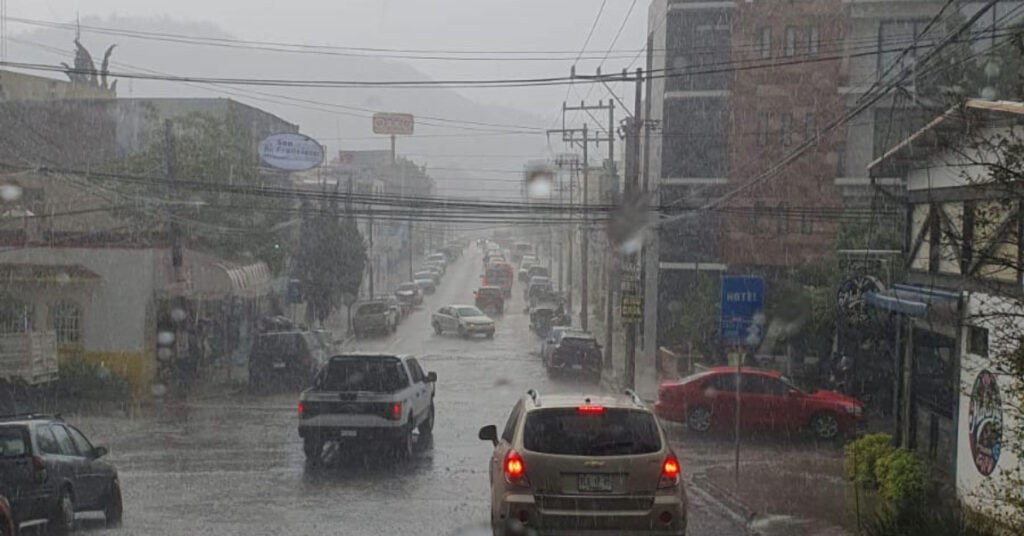
From western Sinaloa down to Chiapas, afternoon thunderstorms will be widespread, fueled by atmospheric instability and plentiful tropical moisture. Chiapas is under a heavy-rain alert, with 25–50 mm of rain possible—enough to trigger puddles, localized flooding and even mudslides in the steep terrain. Guerrero, Michoacán, Oaxaca and the Yucatán Peninsula can expect intermittent showers (5–25 mm), while isolated sprinkles (0.1–5 mm) may reach Guanajuato, Querétaro, Hidalgo, Mexico City, Tlaxcala and parts of the State of Mexico.
An expansive anticyclonic circulation aloft and very low humidity at the surface will keep most of Mexico in a hot to very hot regime. Daytime highs of 40–45 °C will scorch Sonora’s southern reaches, western Chihuahua, northeast Coahuila, central Nuevo León, eastern San Luis Potosí, southern Durango and across the Pacific-coastal states of Sinaloa, Nayarit, Jalisco, Colima, Michoacán, Guerrero and Oaxaca. Coastal Campeche and southwestern Yucatán will also breach the 40 °C mark. Slightly cooler but still torrid conditions of 35–40 °C are forecast for Baja California Sur, Aguascalientes, Guanajuato, Querétaro, Hidalgo, Chiapas, Tabasco and Quintana Roo, with Baja California, Mexico City and Tlaxcala topping out at 30–35 °C.
Hour-by-hour minimums this morning plunged into near-freezing territory in high-altitude northwestern zones. Mountainous spots in Baja California, Chihuahua and Durango saw lows of –5 to 0 °C with frost; Sonora’s highlands and parts of the State of Mexico and Puebla dipped to 0–5 °C. Today’s coldest reading was 9.9 °C in Toluca; Pachuca and Tlaxcala registered 12.0 °C, while the Airport in Mexico City dipped to 16.0 °C.
Coastal interests should brace for significant wave action. Swells of 1.5–2.5 meters will pound the western shores of the Baja California Peninsula, sweep the Pacific coasts of Jalisco, Colima, Michoacán, Guerrero, Oaxaca and Chiapas, and throw breakers along the Gulf coast in Tamaulipas and Veracruz. Mariners and beachgoers are advised to exercise caution and heed local advisories.
Yesterday’s extremes underscore the stakes: Monterrey baked under 44.0 °C, and Campeche and Matlapa, SLP, each hit 42.2 °C. Ciudad Victoria climbed to 41.4 °C, and Tuxtla Gutiérrez and Torreón peaked at 41.0 °C. On the flip side, San Pedro Nichtalucum in Chiapas recorded the heaviest single-site rainfall with 35.0 mm, while Altzomoni in the State of Mexico saw just 1.0 mm.
In the Valley of Mexico, today began under scattered clouds and mist, with cool conditions in the highlands of the State of Mexico. Afternoon temperatures will climb to 31–33 °C in Mexico City and 28–30 °C in Toluca. Isolated afternoon thunderstorms—accompanied by lightning—are possible, and winds will vary from 10 to 20 km/h with gusts up to 50 km/h.
On the Baja California Peninsula, mountain areas shivered under cold morning lows before warming to highs of 30–35 °C. Dust-laden westerlies will gust up to 70 km/h in Baja California, with slightly lighter but still turbulent conditions spilling into Baja California Sur.
The North Pacific corridor will see similar contrasts: chilly highland mornings give way to 40–45 °C afternoons under strong gusty winds and episodic dust storms. The Central Pacific states will bake under a heat wave, interrupted only by scattered showers in Michoacán and gusty southwest winds that may stir localized dust.
Southern Pacific states face the greatest flood risk. Chiapas authorities warn of heavy rains that could spark flash floods and mudslides, while Guerrero and Oaxaca share scattered storms. Coastal winds in the Isthmus of Tehuantepec are forecast at 50–70 km/h, heightening maritime and land-based hazards.
Along the Gulf, Tamaulipas could see afternoon thunderstorms and a continuation of intense southerly gusts, creating dusty conditions inland. Veracruz and Tabasco remain rain-free but will swelter under highs of 35–40 °C, with winds of 20–30 km/h raising the heat index.
Finally, the Yucatán Peninsula will experience a hot, humid day with no significant rainfall expected. Afternoon gusts of up to 50 km/h will sweep east-southeast across Campeche, Yucatán and Quintana Roo, where temperatures will flirt with 35 °C.
Residents and travelers are urged to stay hydrated, limit outdoor activity during peak heat hours, secure loose objects against strong gusts and monitor local alerts for storm-related hazards, flooding and potential wildfire ignitions under today’s blustery conditions.