Forecasters track tropical cyclone Cosme and a second low pressure zone with a high chance of becoming storm Barbara, threatening Mexico’s Pacific coast over the next week.
Forecasters with the National Meteorological Service (SMN) report that the Pacific Ocean remains under close watch as two low pressure zones show signs of strengthening. One system has already earned the name Cosme after its rapid development, and another could become Barbara if it forms first. Both systems could directly affect Mexico’s southern and western Pacific coasts in the coming days.
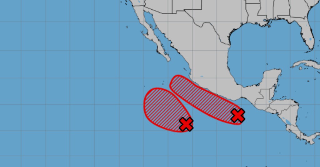
As of Friday morning, the second low pressure zone sits about 820 kilometers south-southwest of Punta San Telmo, Michoacán. It is moving west-northwest over warm ocean waters. SMN forecasters assign it a 50 percent chance of developing into a tropical cyclone within 48 hours, rising to an 80 percent chance within seven days. Its swift organization has already led to it being designated tropical cyclone Cosme, catching meteorologists’ attention for its fast formation.
The first low pressure area, meanwhile, lies roughly 315 kilometers south-southeast of Bahías de Huatulco, Oaxaca. It shows a 50 percent chance of storm formation within 48 hours and a 70 percent chance over the next seven days. If this zone develops before its counterpart, SMN will name it Barbara. Both systems track over open water but could turn northward toward land once they gain strength.
Residents along Oaxaca’s coastline should monitor updates closely. Tropical cyclone Cosme’s projected path keeps it well offshore for now, but forecasters caution that any northward shift could bring heavy rains and rough seas to coastal communities. Fishermen and small boat operators are already advised to avoid the open Pacific until further notice. Wave heights off Michoacán and Guerrero could rise significantly if Cosme maintains its current pace.
If Barbara forms and follows a similar track, it would pose additional risks to coastal areas already on alert for Cosme. Heavy rainfall from two nearby systems could trigger flooding and mudslides in mountainous regions. Local officials in Oaxaca and Chiapas have activated emergency protocols to prepare shelters and stock supplies. At-risk communities, especially those near riverbanks, should stay informed about potential evacuation orders.
SMN director in Mexico City, Claudia Ruiz, said, “Our teams are tracking both low pressure zones around the clock. Residents should sign up for local alerts and avoid coastal activities until conditions improve.” She noted that the Pacific’s warm sea surface temperatures often fuel quick intensification, making early monitoring crucial. Ruiz added that current data suggest Cosme could reach tropical storm strength by Saturday evening, while the second zone may follow suit by midweek.
Historical data show that late May and early June mark the start of the Eastern Pacific hurricane season, which runs through November. In recent years, storms forming this early have sometimes turned into major weather events later in the season. In 2021, for example, Hurricane Enrique formed in early June and affected parts of Mexico’s Pacific coast with torrential rain. Officials say modern satellite monitoring and improved forecasting help communities prepare sooner than in the past.
State civil protection agencies have begun distributing sandbags to flood-prone areas along Oaxaca’s coastal plains. Port authorities in Puerto Escondido and Huatulco have suspended small-vessel operations, and schools in low-lying regions have prepared to close if heavy rains materialize. Meanwhile, hotels and resorts along the Riviera Nayarit and Baja California Sur are reviewing storm-response plans, although those regions sit farther north of the current disturbance locations.
Cosme’s rapid development underscores the need for mariners to stay informed. The SMN issues marine advisories twice daily through its website and social media channels. Its latest bulletin warns that Cosme’s associated showers and thunderstorms could extend as far north as Jalisco by late Saturday. Even areas that do not see direct landfall should expect high surf and dangerous rip currents.
Experts remind the public that initial forecasts can change rapidly when systems are in formative stages. “We rely on updated satellite images and reconnaissance data to adjust tracks,” said Enrique Vásquez, a senior meteorologist at SMN. He stressed that slight shifts in wind patterns can alter a storm’s course by hundreds of kilometers. For now, vigilance is the best defense.
Coastal communities are urged to review emergency kits, secure loose outdoor items, and plan safe routes to higher ground. Anglers and surfers should heed warnings from the Mexican Navy’s maritime division, which has issued small craft advisories for several Pacific ports. With two potential storms on the horizon, authorities say residents must prepare for heavy rain, strong winds, and hazardous seas in the coming week.