


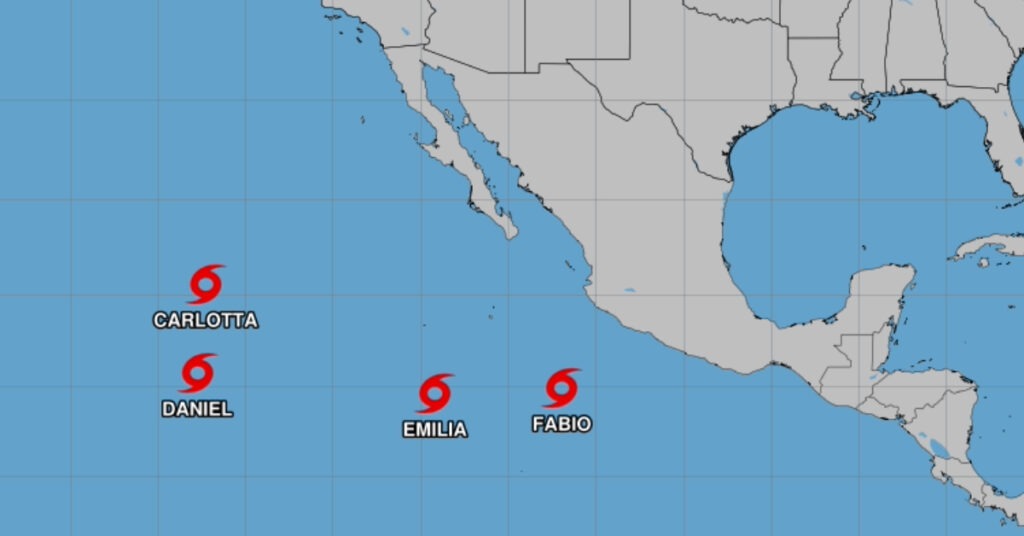
The Pacific coast of Mexico is currently facing a significant meteorological challenge as four tropical storms—Fabio, Carlotta, Daniel, and Emilia—hover over the ocean. These storms are causing concern among meteorologists and residents along the Mexican coast, with authorities urging caution and preparedness in affected areas. Here’s a detailed look at the current status and projections for each storm.
Tropical Storm Fabio
As of 8:00 AM MST (1500 UTC), the center of Tropical Storm Fabio was located near latitude 14.8 North and longitude 106.9 West. The storm is moving northwest at approximately 12 mph (19 km/h), a trajectory expected to persist with increasing speed today. A turn toward the west is anticipated by Tuesday, continuing into Wednesday.
Fabio’s maximum sustained winds are around 40 mph (65 km/h), with higher gusts observed. Meteorologists predict some strengthening of Fabio throughout the day, but the storm is expected to weaken thereafter. Projections indicate that Tropical Storm Fabio will be absorbed by Tropical Storm Emilia by Wednesday night or Thursday. Currently, tropical-storm-force winds extend outward up to 70 miles (110 km) from Fabio’s center.
Tropical Storm Carlotta
Located near latitude 20.4 North and longitude 127.2 West at 8:00 AM PDT (1500 UTC), Tropical Storm Carlotta is traveling westward at about 9 mph (15 km/h). This motion is expected to continue today, albeit at a slightly reduced speed. A shift to a west-southwestward trajectory is predicted for Tuesday, with the storm likely dissipating soon after.
Carlotta’s maximum sustained winds are currently near 45 mph (75 km/h), with higher gusts. The storm is forecast to weaken over the next 48 hours, possibly transitioning into a post-tropical low at any point. Tropical-storm-force winds extend outward up to 70 miles (110 km) from the storm’s center.
Tropical Storm Daniel
As of 8:00 AM PDT (1500 UTC), the center of Tropical Storm Daniel was located near latitude 15.6 North and longitude 127.7 West. The storm is moving northeast at approximately 14 mph (22 km/h). Forecasts suggest that Daniel will shift to a northern direction tonight and tomorrow, eventually turning west by mid-week.
Daniel’s maximum sustained winds are around 40 mph (65 km/h), with higher gusts. A weakening trend is anticipated, and Daniel is expected to become a post-tropical remnant low by mid-week. Currently, tropical-storm-force winds extend outward up to 70 miles (110 km) from the storm’s center.
Tropical Storm Emilia
At 8:00 AM MST (1500 UTC), Tropical Storm Emilia was positioned near latitude 14.5 North and longitude 114.1 West. Emilia is moving south-southwest at about 5 mph (7 km/h), a motion expected to persist through today. A sharp turn toward the northwest or north-northwest is projected by early Tuesday.
With maximum sustained winds of approximately 45 mph (75 km/h) and higher gusts, Emilia is expected to strengthen gradually over the next few days. Tropical-storm-force winds extend outward up to 70 miles (110 km) from its center.
Preparations and Precautions
As these storms continue their courses, Mexican authorities and residents along the Pacific coast are advised to remain vigilant. Although these storms are currently offshore, their trajectories and intensities can change rapidly, potentially bringing heavy rains, strong winds, and rough seas to coastal areas. The National Meteorological Service of Mexico and other relevant agencies are closely monitoring the situation, issuing advisories as necessary.
Residents and visitors in potentially affected areas are urged to stay informed through official channels and prepare for possible impacts. Precautionary measures include securing property, preparing emergency kits, and having evacuation plans ready if required. Maritime activities in affected regions should also be approached with caution due to potentially hazardous sea conditions.