
Tropical Storm Alvin will move southwest of Colima and Jalisco on May 30, bringing heavy to intense rains, strong winds, and elevated waves along Mexico’s Pacific coast, while additional weather systems fuel storms and heat waves nationwide.
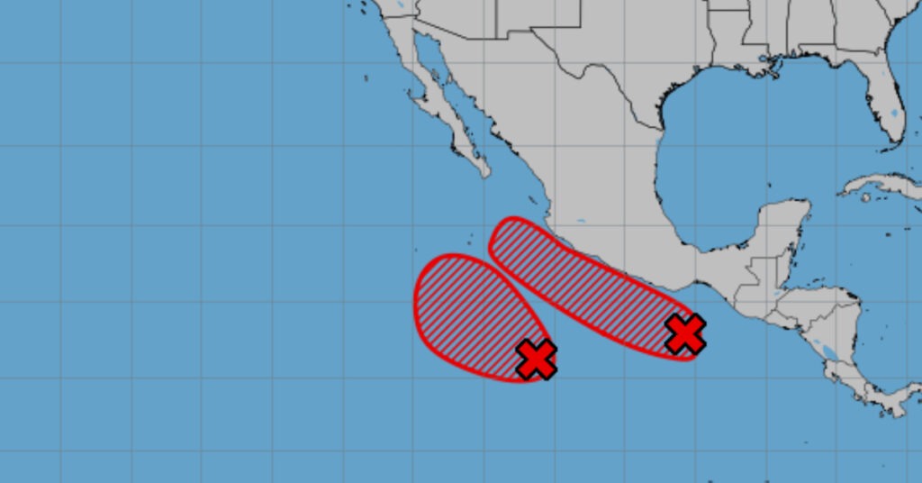
Tropical Storm Alvin, the first named system of the 2025 Pacific hurricane season, is expected to pass southwest of the Colima and Jalisco coasts on Friday, May 30. According to the National Meteorological Service (SMN), Alvin’s circulation will generate cloud bands over western Mexico and Baja California Sur, triggering heavy rains with very strong to intense downpours (50–75 mm) in Nayarit, Jalisco, Colima, and Michoacán, as well as showers in Baja California Sur and southern Sinaloa. Coastal winds will reach 40–50 km/h with gusts of 60–80 km/h in Jalisco, Colima, and Michoacán, with conditions ripe for waterspout formation off Jalisco and Colima. Elevated seas are forecast at 3.0–4.0 m, rising to 5.0 m along the coasts of Jalisco, Colima, and Michoacán; 2.0–3.0 m in Nayarit (up to 4.0 m); and 1.0–2.0 m in Baja California Sur (up to 3.0 m).
A mid- and upper-level cyclonic circulation, linked to the subtropical jet stream over northwest Mexico, will interact with atmospheric instability, an out-of-season cold front draped along the northern border, and a low-pressure trough over the Northern Tableland. This combination is set to produce strong wind gusts and heavy to very heavy rains across northern states, with intense rainfall in Coahuila and Nuevo León. The cold front itself will weaken by day’s end but not before delivering gusty winds of 60–80 km/h and downpours along the border regions.
Meanwhile, low-pressure channels interacting with atmospheric instability and the influx of warm, humid air from the Pacific, Gulf of Mexico, and Caribbean Sea—augmented by a tropical wave nearing the Yucatán Peninsula—will spark showers and heavy rains accompanied by lightning and possible hail across central, eastern, southern, and southeastern Mexico, including the Valley of Mexico and the Yucatán Peninsula. Very heavy to intense rainfall is expected in Tlaxcala, Puebla, Veracruz, and Oaxaca.
The hot to very hot environment will persist nationwide, with maximum temperatures of 40–45 °C forecast for Sonora, Sinaloa, Nayarit, Guerrero, Tabasco, Campeche, and Yucatán, and 35–40 °C in most other states, including Quintana Roo. A heat wave will dominate the Yucatán Peninsula (Campeche, Yucatán, and Quintana Roo), raising heat-related health risks.
Rainfall Forecast for May 30, 2025
- Very heavy to intense (75–150 mm): Coahuila, Nuevo León, Puebla, Veracruz, Oaxaca
- Heavy to very heavy (50–75 mm): Jalisco, Colima, Michoacán, Chiapas, Chihuahua, Durango, Zacatecas, Tlaxcala
- Showers with heavy downpours (25–50 mm): Nayarit, Tamaulipas, San Luis Potosí, Guanajuato, Querétaro, Hidalgo, State of Mexico, Guerrero
- Intervals of showers (5–25 mm): Baja California Sur, southern Sinaloa, Aguascalientes, Mexico City, Morelos, Tabasco
- Isolated showers (0.1–5 mm): Baja California, Sonora, Campeche, Yucatán, Quintana Roo
Wind and Wave Highlights
- Coastal winds: 40–50 km/h with gusts of 60–80 km/h in Jalisco (coast), Colima, Michoacán (coast); conditions for waterspouts off Jalisco and Colima.
- Interior winds: 20–30 km/h with gusts of 40–60 km/h in Baja California Sur, Sinaloa, Nayarit.
- Wave heights: 3.0–4.0 m rising to 5.0 m in Jalisco, Colima, Michoacán; 2.0–3.0 m rising to 4.0 m in Nayarit; 1.0–2.0 m rising to 3.0 m in Baja California Sur.
The SMN warns that heavy to intense rainfall may lead to puddles, urban flooding, and landslides in vulnerable areas, while strong gusts pose risks of fallen trees and downed billboards.
Residents in affected regions are urged to monitor official SMN updates, secure outdoor objects, and have emergency plans ready. Coastal communities should heed maritime advisories and avoid venturing into rough waters as the combined impacts of Tropical Storm Alvin and other weather systems unfold across the country.