
Heavy rains in eastern Mexico today (May 28, 2025) could trigger flooding, landslides and whirlwinds from Puebla to Chihuahua. Read for detailed forecast.
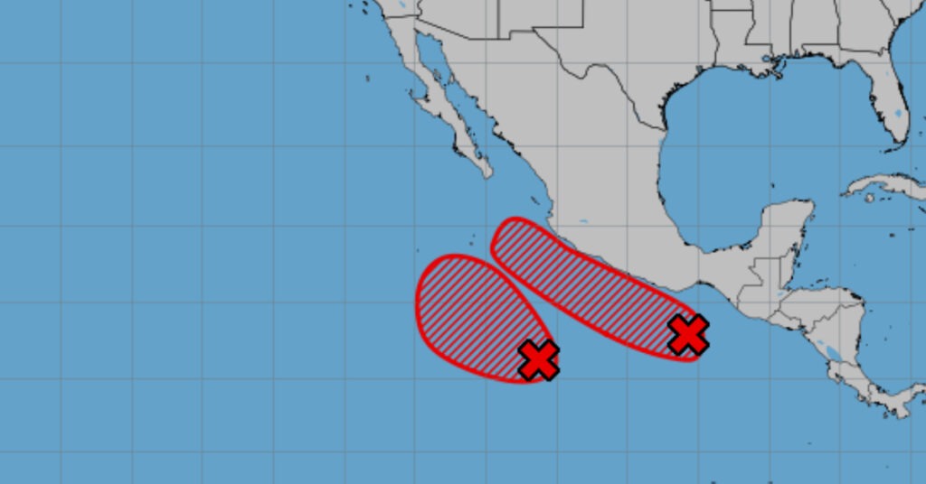
On May 28, 2025, heavy to very heavy rains spread across eastern and southeastern Mexico, while the nation’s northeast braces for possible whirls or tornadoes. A tropical cyclone skirting south of the Michoacán and Colima coasts will inject deep moisture and unstable air into the west, center and south. In the northeast, an out-of-season cold front interacting with the subtropical jet and warm Gulf inflow will fuel downpours, gusty winds and a tornado risk. In the southeast, a low-pressure trough drawing moisture from three seas will pile up intense showers and potential hail.
A tropical cyclone south of Michoacán and Colima takes center stage today. Its outer bands will detach into convective cells that sweep westward, centerward and southward. Expect heavy to very heavy rains accompanied by frequent lightning across Michoacán, Colima and Guerrero. Coastal areas there will endure strong gusts and waves reaching up to three meters, prompting small-craft advisories and localized flooding along beaches and coastal roads.
Farther north, an atypical front in its dissipation stage collides with a subtropical jet streak and Gulf humidity. This setup will generate wind gusts of 60–80 km/h, scattered to very heavy showers in Coahuila, Nuevo León and Tamaulipas, and a risk of whirlwinds or tornadoes in northeastern Chihuahua and northwestern Coahuila. Dust storms may whip through Durango and Zacatecas as the same system channels dry, gusty winds across the northern plateau.
Meanwhile, in southeastern Mexico, a broad low-pressure channel feeding on Pacific, Gulf and Caribbean moisture will drive heavy to very heavy rains from Veracruz through Chiapas. Veracruz, Puebla and Oaxaca could each record 75–150 mm of rain, heightening the threat of flash floods and landslides in steep terrain and along swollen rivers. Embedded thunderclouds could drop hail the size of marbles, especially over Oaxaca’s highlands and Veracruz’s central zones.
Across affected regions, persistent downpours may leave streets underwater, clog drainage systems and trigger slopes to give way. In drought-stricken states like Sonora, Sinaloa and Durango, gusting winds of 30–40 km/h with stronger bursts will fan brush fires, risking fast-moving wildfires. Elsewhere, wind gusts up to 80 km/h could topple trees and billboards, obstructing roads and damaging power lines.
Rainfall today breaks down as follows:
- Very heavy (75–150 mm): Puebla, Veracruz, Oaxaca
- Heavy to very heavy (50–75 mm): Coahuila, Nuevo León, Tamaulipas, San Luis Potosí, Querétaro, Hidalgo, Morelos, Michoacán, Guerrero, Chiapas
- Moderate (25–50 mm): Jalisco, Colima, Guanajuato, State of Mexico, Mexico City, Tlaxcala
- Light to moderate (5–25 mm): Chihuahua, Durango, Zacatecas, Aguascalientes, Tabasco, Quintana Roo
- Isolated light (<5 mm): Nayarit, Campeche, Yucatán
Winds and waves will compound hazards:
- Northeast plateau: 30–40 km/h with 60–80 km/h gusts in Nuevo León and Tamaulipas; possible tornadoes in Chihuahua and Coahuila; dust storms in Durango, Zacatecas
- Pacific and Gulf coasts: 10–20 km/h with 40–60 km/h gusts along Jalisco, Colima, Michoacán, Guerrero, Oaxaca, Chiapas; waves of 2.0–3.0 m on Colima, Michoacán, Guerrero; 1.5–2.5 m on Oaxaca and Chiapas
- Yucatán Peninsula: 10–20 km/h with 40–60 km/h gusts in Campeche, Yucatán, Quintana Roo; choppy seas off Cancun
Regional outlook
Valley of Mexico: Morning clouds give way to showers and heavy downpours by afternoon in Mexico City and Toluca. Flooding, landslides and poor visibility on mountain roads are likely. Expect lows of 13–15 °C in the capital, highs of 22–24 °C; Toluca 10–12 °C minimum, 19–21 °C maximum. Winds will vary at 10–20 km/h with gusts to 40 km/h.
Baja California & North Pacific: Dry skies prevail across the peninsula; morning fog on Baja’s west coast. Afternoon heat builds to 35–40 °C with 40–60 km/h gusts and occasional dust storms in Sonora and Sinaloa.
Central & South Pacific: Michoacán sees very heavy rains; Jalisco and Colima heavy showers. Nayarit sees scattered storms. Guerrero faces heavy rainfall; Oaxaca very heavy rain and hail risk; Chiapas heavy showers. Temperatures climb to 30–40 °C with gusts to 60 km/h.
Gulf & Yucatán: Veracruz registers heavy rain; Tamaulipas very heavy rain and possible tornadoes. Tabasco sees thunderstorms. Campeche’s coast hits 40–45 °C with showers in Quintana Roo and scattered rain in Campeche and Yucatán.
Northern & Central Tableland: Coahuila, Nuevo León, San Luis Potosí and Hidalgo record very heavy downpours, flash flood and hail threats. Showers extend into Chihuahua, Durango and Zacatecas. Heat waves bake Coahuila, Durango and Sinaloa under 40–45 °C highs.
In the last 24 hours, San Cristóbal de las Casas topped rainfall with 65 mm, Acapulco saw 52 mm, Tacotalpa 33 mm and Tezoyuca 30 mm. Mérida and Campeche broiled at 41.5 °C; Choix 41.2 °C; Hermosillo 40.5 °C; Torreón 40.4 °C. Meanwhile, mountain stations dipped to single digits: Temosachic hit a low of 5.2 °C; Toluca 12.0 °C.
Residents and travelers should stay alert, heed local advisories and avoid flood-prone zones until conditions improve.