
A rare, out-of-season cold front sweeping down from the northern border is interacting with a dry line over Chihuahua and Coahuila, while multiple low-pressure channels and the subtropical jet stream amplify atmospheric instability across the country. Today’s forecast calls for heavy to very heavy rainfall in the northeast, intense showers in the center and south, strong winds—and pockets of extreme heat.
Northeast: Showers, Gusty Winds and Tornado Risk
Coahuila, Nuevo León, Tamaulipas and San Luis Potosí can expect heavy to very heavy rains (50–75 mm), with isolated storms dropping up to 150 mm in Puebla, Veracruz, Oaxaca and Chiapas. In Chihuahua, steady northerly winds of 30–40 km/h will gust up to 80 km/h, stirring up dust storms. Meteorologists warn of possible whirlwinds or tornadoes in northern Coahuila, northeastern Coahuila, northern Nuevo León and northwestern Tamaulipas.
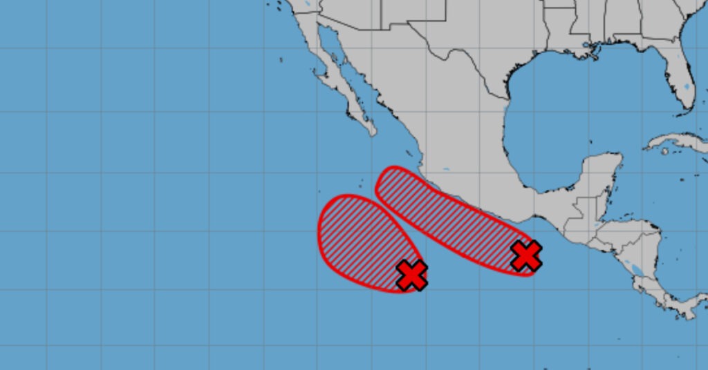
Center and South: Intense Rainfall and Cyclone Watch
A low-pressure channel over central Mexico, fueled by moisture from the Pacific, Gulf and Caribbean, will make landfall south of Guerrero, where it may develop into a tropical cyclone. Expect very heavy rains (75–150 mm) in Puebla, Veracruz, Oaxaca and Chiapas, and heavy downpours (50–75 mm) across Tlaxcala, the State of Mexico, Morelos and Guerrero. Thunderstorms, hail and strong gusts will accompany these storms, raising the risk of flooding, landslides and mudflows.
Hot Zones and Heat Waves
Despite the rain, a heat wave will grip much of the country. Maximum temperatures between 40 °C and 45 °C will scorch Sonora, Chihuahua, Coahuila, Nuevo León (north), Tamaulipas (south), eastern San Luis Potosí and a broad swath of western and southern states—including Jalisco, Colima, Michoacán, Guerrero, Oaxaca, Chiapas, Campeche and Yucatán. A slightly cooler but still sweltering 35–40 °C is forecast for Baja California, Baja California Sur, Zacatecas, central Guanajuato, Querétaro, Hidalgo, southwestern State of Mexico, Morelos, Puebla and Quintana Roo.
Coastal Winds and Waves
Coastal regions face large seas and gusty winds. The Pacific coasts of Guerrero, Oaxaca and Chiapas will see waves of 2.0–3.0 m, while the western shore of the Baja California Peninsula will register 1.5–2.5 m swells. Wind gusts of 40–60 km/h are expected along both coasts, with dust storms possible in Baja California, Sonora, Sinaloa, Nayarit, Durango and San Luis Potosí.
Regional Forecast Highlights
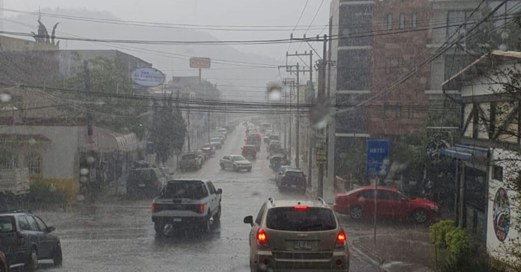
- Mexico City & State of Mexico: Morning drizzle and fog give way to afternoon showers and heavy downpours, especially in the State of Mexico. Expect 13–15 °C lows and 24–26 °C highs in the capital, with 19–21 °C in Toluca. Southwesterly winds will gust up to 50 km/h.
- Baja California Peninsula: No rain but fog banks on the western coast. Morning temperatures will stay cool, rising to warm or hot by afternoon, with 20–30 km/h northwest winds and gusts to 60 km/h.
- Northern Tableland: Very heavy rains in Coahuila and Nuevo León, heavy showers in San Luis Potosí and isolated drizzles in Chihuahua, Durango and Aguascalientes. Afternoon highs to 45 °C in Chihuahua and heat waves in Coahuila and Durango. Winds gusting 80 km/h in the north.
- Gulf of Mexico: Heavy to very heavy rains in Veracruz and Tamaulipas, with tornado risk in northwestern Tamaulipas. Winds of 30–40 km/h will gust to 80 km/h offshore.
- Yucatán Peninsula: Scattered showers only in Quintana Roo; heat wave conditions along the Campeche coast with gusty east-southeast winds.
Advisory:
Heavy rainfall may cause flooding, ponding and landslides in mountainous and low-lying areas. Rising rivers and streams pose a flood risk. Gusty winds could down trees and power lines. Heat-stroke precautions are advised in regions under the heat wave watch. Travelers and residents should stay alert to weather updates and heed any local warnings.