


Tropical Storm “John” formed early on Monday, September 23, in the Pacific Ocean after originating as Tropical Depression Ten-E over the weekend. The National Meteorological Service (SMN) has confirmed that the storm will likely evolve into a hurricane by Monday afternoon, affecting the southern and southeastern regions of Mexico in the coming days.
Current Location and Storm Characteristics
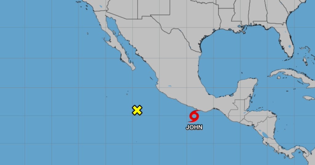
As of 9:00 AM on Monday, “John” is located 165 km south of Punta Maldonado, Guerrero, and 185 km southwest of Puerto Escondido, Oaxaca. The storm is moving north at a speed of 6 km/h, with maximum sustained winds of 110 km/h and gusts reaching 140 km/h.
Forecasted Path and Intensity
“John” is projected to strengthen rapidly, becoming a Category 1 hurricane by Monday afternoon with sustained winds of 140 km/h and gusts of 165 km/h. At that point, the storm will be situated approximately 110 km southwest of Lagunas de Chacahua, Oaxaca, and 130 km south-southeast of Punta Maldonado, Guerrero.
By the early hours of Tuesday, September 24, “John” is expected to intensify further into a Category 2 hurricane. The storm will be located 40 km southwest of Lagunas de Chacahua and 90 km west-southwest of Puerto Escondido, Oaxaca.
By Tuesday afternoon, “John” is forecasted to make landfall, entering Mexican territory 5 km northeast of Lagunas de Chacahua and 60 km west-northwest of Puerto Escondido.
Weather Impacts Across Mexico
The SMN has issued rain and wind forecasts for multiple regions of Mexico due to the presence of “John.” The following areas are expected to experience significant rainfall and strong winds:
- Oaxaca and Guerrero: Extraordinary rainfall is forecast, along with winds reaching speeds of 100 to 120 km/h and waves between 3 and 5 meters along the Oaxacan coast. The coasts of Guerrero will experience gusts of 40 to 60 km/h, with waves between 1 and 3 meters.
- Chiapas: Torrential rains are expected.
- Veracruz and Puebla: Heavy rains are forecast.
- Tabasco, Michoacán, and Morelos: Very strong rainfall is expected.
- State of Mexico: Strong rainfall is anticipated.
Additional Meteorological Phenomena
In addition to Tropical Storm “John,” other meteorological systems are influencing the weather in Mexico:
- Low-Pressure Zone in the Caribbean: A low-pressure system with a high probability of becoming a tropical cyclone is circulating over the northwest Caribbean Sea. This system will cause heavy rains and winds of 40 to 60 km/h in Campeche, Yucatán, and Quintana Roo.
- Cold Front No. 3: This cold front is currently located along Mexico’s northern border. It is expected to bring very heavy rains to Chihuahua, shower intervals in Coahuila, and strong gusts of wind, with the possibility of dust storms in Coahuila.
Extended Weather Outlook
Throughout the country, additional precipitation is expected due to a low-pressure channel stretching across northern and central Mexico, combined with humid air from the Gulf of Mexico and the Pacific Ocean. Rain forecasts for other regions include:
- Tabasco: Heavy rains.
- Michoacán and Durango: Very strong rainfall.
- Tlaxcala, Mexico City, Tamaulipas, San Luis Potosí, Nuevo León, Colima, Jalisco, Nayarit, and Sinaloa: Strong rains.
- Hidalgo, Querétaro, Guanajuato, Aguascalientes, and Zacatecas: Showers with potential electrical discharges.
The SMN also forecasts a warm to hot environment across much of the country, with temperatures exceeding 40°C in parts of Baja California and Sonora.
Precautionary Measures
Residents in affected areas, particularly along the coasts of Oaxaca and Guerrero, are urged to follow instructions from local authorities and the SMN regarding safety measures. Coastal areas should be prepared for potential flooding, high winds, and storm surges. Additionally, travelers and residents are advised to remain informed about changing weather conditions as the storm approaches land.
Tropical Storm “John” is expected to remain a significant weather event for Mexico this week, with widespread impacts anticipated across both coastal and inland areas.